
Emergency Management using Drones - Public Safety Applications
Drones have been changing the way public safety operates. If you do some light research on the topic, numerous departments use drones in their daily Public Safety Operations. Today I would like to focus on one area of Public Safety that rarely uses drones. Still, they would have the most significant impact on the daily operations within this specific sector. This area is known as Emergency Management.
This branch of Public Safety is often shadowed by Fire, Law Enforcement, and Emergency Medical Services. Emergency Management plays a vital role in the safe and effective operations of minor and significant scale events. These events can vary from small parades up to large scale disasters. Emergency Management can use drones to aid their entire operation. Drone data can and will augment and tailor most of how Emergency Management operates daily. Let me explain
EVENT/INCIDENT PREPLANNING-
Emergency Management begins with planning. But, first, data is collected and analyzed to determine the best course of action with available resources. Data collection can be quick, or it may be complex; either way, drones can quickly gather the data for most preplanning. Let me give two examples:
Example one-
An event is taking place, and the team has been able to use a small parking lot as the staging area. The team needs to have ten 20×20 foot tents set up for the event. They are not sure if the lot is big enough for ten tents. They can use a drone to map the parking lot to give the team the necessary measurements to ensure the tents will fit in the lot properly.
Example two-
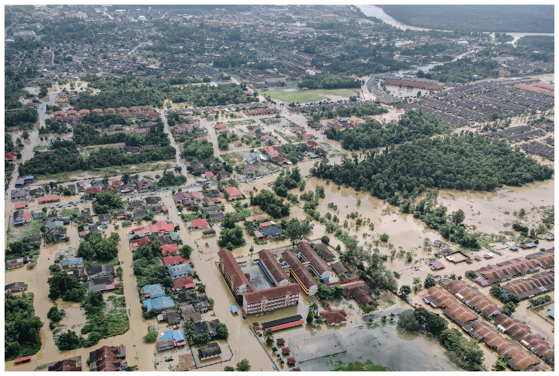
An area has been issued a flash flood warning for an approaching storm. The team has 12 hours to gather the data to pre plan for the event. When collecting data, the last topographical data the team has access to is several years old. Since the data, there has been a lot of development in the area. Topographical maps are CRITICAL to pre planning such an event. Water will go to low-lying areas, and it’s the team’s job to pinpoint these areas and mitigate the risks.
Teams can use drones to gather data to create updated topographical maps that reflect the current conditions in the area. These maps give the team the most accurate data because it is not outdated. Accurate data allow the team to allocate resources appropriately, provide warning, and help evacuate those with the highest chance of potential danger.
Drone are excellent tools for collecting data and information. Not only can drones be used for planning, but they can also support the operation.
OPERATIONAL SUPPORT-
Emergency Management Teams can use drones to assess a situation and give live data/ video of the event. Emergency personnel can use this intel to equip themselves properly. In addition, drones can provide important updates regarding the current situation.
Data provides fewer surprises for the teams operating in the field; it allows for a safer, more controlled operation. Data is a potent tool in Emergency Operations. The formula is simple: The more data we have, the better we can plan, and the better we plan, the more effective the operation will be. Teams can use the same data to determine if a plan is adequate or needs to be restructured.
OPERATIONAL MAINTENANCE-
The emergency management team must evaluate the situation consistently for an operational plan to stay on course. Detailed assessments of the operation are collected and analyzed to see if the plan is adequate or needs improvement. The team can use drone data in various ways during this process. Data collected brings tangible data that can not be mistaken. Drones can take photos and videos before and after to showcase the current conditions, improvements, or decline of areas in question. Drones can also gather the necessary data to create 3D models and 2D maps.
The 3D models can be used to inspect a building for structural integrity remotely and can also be used to show specific areas of concern. 3D models allow the viewer to view a particular place in great detail and from any angle. These virtual inspections can save resources by allowing a person to remotely view multiple points of interest. Drones also reduce time significantly as there is no movement of personnel from site to site. This also reduces the number of personnel in harm’s way.
TRANSFERABLE DATA-
Drones can create 2D orthorectified maps very quickly. Drones allow operators to have reduced time in harm’s way. Since drones can make 2D maps from the air, it also enables the members operating to keep a distance from potential hazards. Drone mapping is much faster than traditional surveying. Drone data can produce survey-grade results. However, this is a long process and requires extra resources, specialized drones, and equipment. The standard mapping data provided by drones is accurate enough for an Emergency Operation.
Operators can use the GPS data just fine if a GPS marker is a foot off(the average drone data is generally within 3-6 inches of a survey grade point). The best part of drone data is captured autonomously. Drones can repeat the flight over and over. This exact repetition of the flight will allow data to be cross-examined with data from a previous flight without the variables of the flight affecting the results. These are just some ways that drones can help maintain awareness of a developing situation. The data compiled throughout the operation can be shared with the relief emergency team or be used post operation briefing during demobilization.
Drones and their intel and data easily find their way into the public safety sector. As a result, there are no shortages of Men and Women who use and rely on the information drones offer. In many cases, Public Safety Operators trust this data with their lives. Emergency Management can use drones to aid their entire operation as well as aid in disaster preparedness. Emergency management plays a vital role in the communities they serve, and drones provide a robust, cost-effective tool to better aid them in their operations. Technology will only continue to evolve, and drones will be able to assist these teams during all phases of their operations.